|
Fracking can
take place with guidance.
The safe way to
do fracking is by using me and my technique combined with a
geologist and to work it out together on whether there are a
minimum of three separate layers of igneous rock between the
ancient water table and the potential oil/gas fields. This would
help to allow for accidental fractures from the fracking to occur
in one or possibly two of the impervious zones only. The third one
would have to remain safe and no contamination to take place for
this to work. I think there is a way to do this by using me and my
technique to check out with the geology of the rock formation
between the ancient water table and the potential oil/gas fields.
Furthermore my
input would help to locate the oil fields beneath the ground plus
locating the ancient water zones if they do cross the oil field.
This method would be to intercept the oil away from the ancient
water zones by remote viewing it is possible to mark out the
ancient water table and if and where it crosses the oil field
beneath the ground. A graph could then be worked out by the
geologist and with the help of my technique of map surveying and
the calculations given by myself and the geologist to work out the
layers of rocks porous and non porous it can be possible to drill
a borehole either side and a safe distance from the ancient water
table down into the oil field/gas field without damaging the
ancient water table.
We can also
determine and work out if there is any potential faults or
fractures within the structures in the given area. The map shows a
potential oil field below the ground. An ancient water zone and
graph shown how it would work outside. This is only remote
surveying of the site needless to say we would have to confirm the
locations and the drilling trials to confirm the geology with a
site visit.
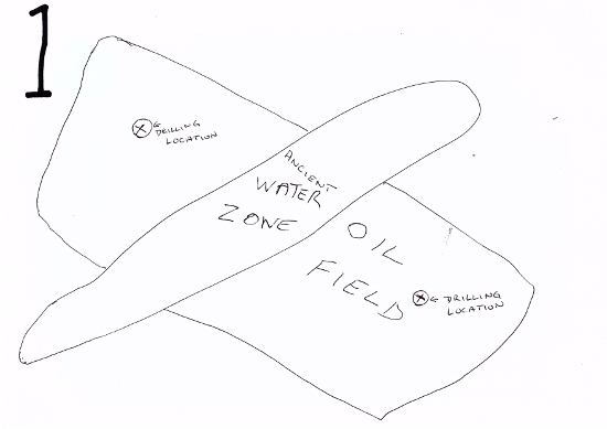
Map
number 1 shows the ancient water zone crossing the
potential oil field and marked out with a cross within a circle is
the drilling location avoiding the ancient water zone.
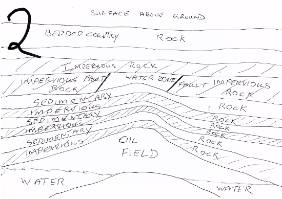
Map
number 2 shows a side elevation giving the impervious
rock areas and the sedimentary rock layers from the surface down
to the potential oil field.
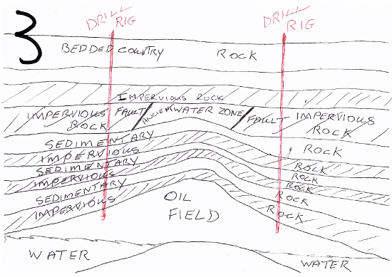
Map
number 3 shows potential drilling areas into the oil
field away from the ancient water zone. The faults have forced the
rock of the sedimentary rock up pushing the impervious rock up and
sideways away creating the trap for the ancient water table to
rise into it.
|