RESEARCH
Surveying Natural Gas Locations Around the World
| COUNTRY |
AMOUNT OF GAS |
| Algeria |
140 billion cubic meters
|
| Australia |
390 billion cubic meters
|
| Belarus |
212 billion cubic meters
|
| Canada |
195 billion cubic meters
|
| China |
740 billion cubic meters
|
| Egypt |
69 billion cubic meters
|
| France |
590 billion cubic meters
|
| Finland |
105 billion cubic meters
|
|
India |
666
billion cubic meters
|
|
Libya |
90 billion cubic meters |
| Mauritius |
320
billion cubic meters |
| Namibia |
1,200
billion cubic meters & 600 billion cubic meters |
| Netherlands |
700
cubic meters |
| Poland |
340
billion cubic meters & 52 cubic meters |
| Sudan |
500
billion cubic meters |
| Saudi Arabia |
150
billion cubic meters |
|
Serbia |
116
billion cubic meters |
| Ukraine |
1,100 cubic meters |
| United Kingdom |
450
billion cubic meters |
| USA |
530
billion cubic meters |
| USSR |
460
cubic meters |
PLEASE LOOK AT THE GOOGLE EARTH MAPS BELOW WHICH SHOWS
YOU FOUR AREAS OF OIL & GAS FIELDS ON THE BORDERS BETWEEN RUSSIA
AND THE UKRAINE
There is a coding system that I use which
is shown as outlines and markers on the maps as follows:
Green – is for oil only
red is for natural gas only
purple
is for oil & gas deposits
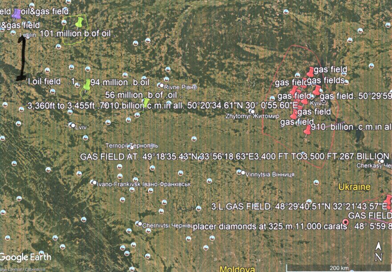
MAP 1
This map borders the boundaries between Russia and
the Ukraine. As you can see to the far west there is oil & gas,
then further east there are oil deposits and further east again
there is a large area of gas deposits which contains 710 billion
cubic meters of gas
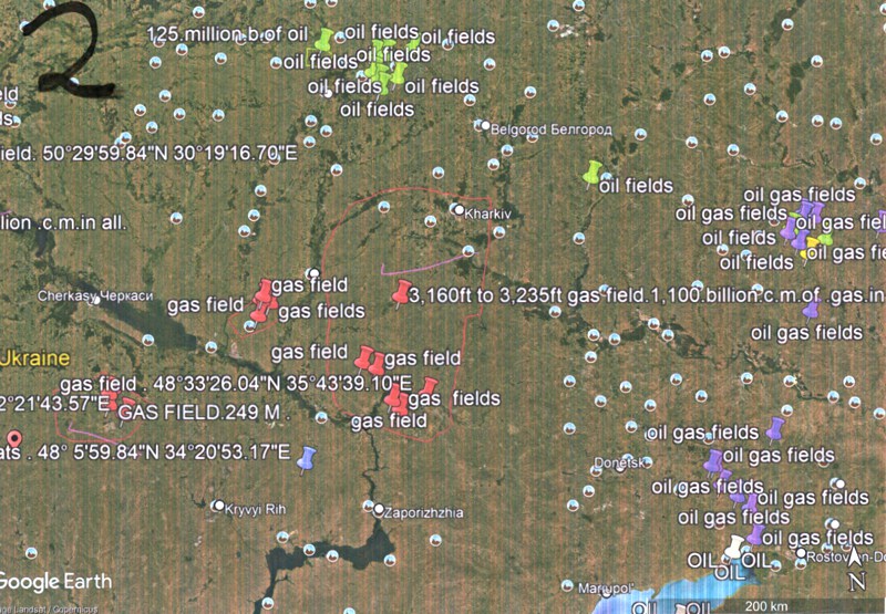
MAP 2
This map is a continuation of map 1 moving to the east. Again you
can see to the north a cluster of green markers indicating oil
fields straggling the border between Russia & the Ukraine. Further
to the south there are gas fields, some of them are marked out
with a red boundary indicating the size of the gas field. Further
to the east again is straggling the borders between Russia & the
Ukraine are oil & gas fields marked out in purple.
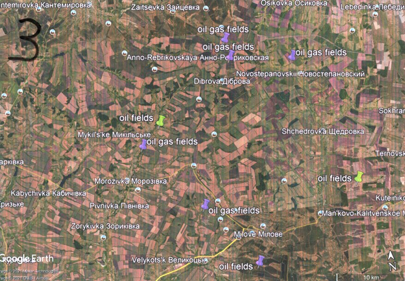
MAP 3
This map shows you the southern
part bordering Russia and the Ukraine using a guide 10km. You will
see from this two potential oil fields and six potential oil & gas
fields.
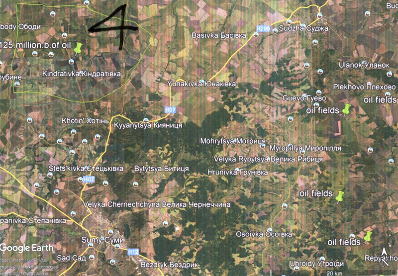
MAP 4
This map
shows a close up at 20km. This oil field is on either side of the
border between Russia and the Ukraine which is interesting to note
perhaps.
MY LATEST RESEARCH INTO FRACKING AND OIL & GAS
IMPLICATIONS HOW TO AVOID DESTROYING ANCIENT WATER SOURCES
please click
here
I worked for Hurricane for 4 years under 2 contracts parts of each
are shown below. Hurricane was satisfied wtih the work that I did
at the time. I did locate several fields on the mainland of
Britain for them over the time I was with them. |
See below for the latest reference from this oil company. I am unable
to mention the name, or location because of the confidentiality
clause. The chief geologist of the company offers the following
testimony to my work:
‘Peter has shown a remarkable ability to identify the presence of
geological structures in the subsurface that could potentially be
hydrocarbon-bearing. In several cases his dowsing has highlighted
areas where oil or gas could be present and which when subsequently
checked against seismic data have indeed shown the presence of viable
leads or prospects. Based on this work, the company has acquired
acreage and identified prospects that it would not otherwise have
considered or recognised. His work has also proved to be a valuable
screening tool when evaluating exploration opportunities offered by
other companies. Having worked with Peter now for several years we
are therefore of the firm opinion that his ... techniques can make a
significant contribution to the success of an exploration company. As
a final comment, our experience has shown that it is important for
both the geologist and Peter to work together in order to get the best
results - from the geologist’s perspective Peter’s work can certainly
make you think again and reconsider the prospectivity of areas that
you may otherwise have dismissed or overlooked, whilst for Peter the
technical and scientific insight provided by the geologist helps him
to fine tune his ... technique to the subsurface geology
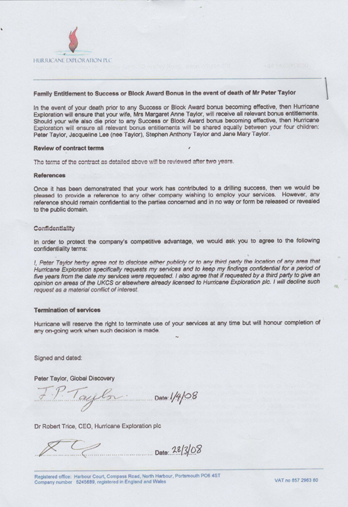
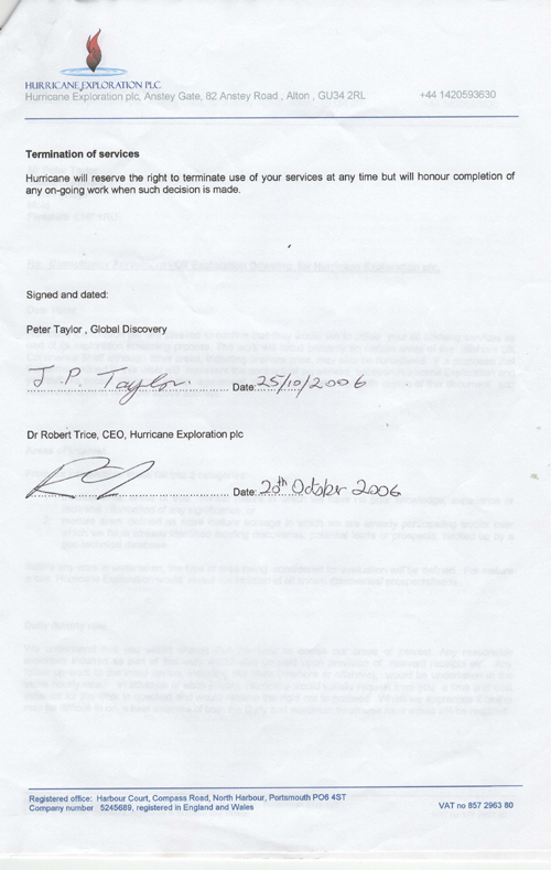
My Contract with Hurricane started in 2006 which was a 2 year contract
followed up by a second period extending to 2008. In 2006 to 2007 I
did quite a bit of work locating potential oil fields for the Company
first of all by remote surveying then as usual on site when I located
a potential oil field west of Salisbury in the area of Bishopstone. I
worked out the depth and quantity recoverable which at a later date I
was called down to Salisbury to work on site as this improves the
accuracy to locate the potential field together with the geologist of
the Company. I was informed that 2 million to 3 million barrel would
be financially feasible. This particular field was indicating a
capacity to recover over 10 million barrels from the site.
Unfortunately they decided not to go ahead with this particular site
as they felt they could pursue and get larger volumes in the West of
Shetlands.
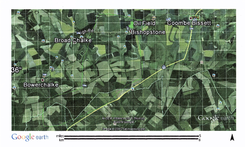
The map above shows the area in question close to Salisbury.
About a year later I had also located by remote surveying an area in
Perthshire further oil fields which again we were both called out to
check the site where I did a depth count and quantity count and
checked out for faulting and fractures whilst I was there. It was
later confirmed that there was a good volume of oil in that area and
in the region that I had predicted on site. A siesmix survey was taken
to support my findings which in due course it did and also indicated
that it would be financially feasible to raise.
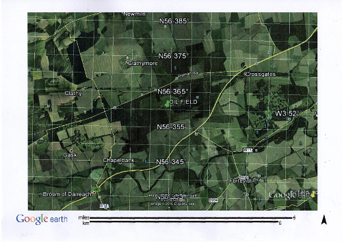
This map indicates the Perthshire area
I was asked later on to check out the West of Shetlands. First of all
on a large planning map bigger than an ordnance survey map. Having
said that the map surveying as always only gives us a guide as to the
potential target area, a site visit is always advisable. The Company
had already marked out some lead on the plan and I was asked to check
out these sites which I duly did. Some of the sites were indicating
oil to me but the porosity of the rock in some cases seemed to be
poor. On other sites I didn't get a good indicator of oil. I marked
out the potential areas that I had a good reaction on. Some were not
on their leads but nearby which I had indicated potential oil. Our
contract finished in 2010 so I am allowed now to pass my thoughts on.
I do believe that if I would have been asked to go out to sea to check
those areas I would have picked up the same areas as the Company has
as this would of confirmed the oil potential fields like I did in
Salisbury and Perthshire. As far as I am aware the field in Perthshire
and Salisbury are still free. For those of you oil men who are looking
for worthwhile oil reserves I know of plenty in and around the UK
itself just contact me.
|